Wrangler for Emergency Events Database.
WEED (Wrangler for Emergency Events Database)
The goal of weed is to make the analysis of EM-DAT and related datasets easier, with most of the pre-processing abstracted away by functions in this package!
Pre Requisites
Installation of the following packages : readxl, dplyr, magrittr, tidytext, stringr, tibble, geonames, countrycode, purrr, tidyr, forcats, ggplot2, sf, rgeos.
You also need a geonames user account if you intend to use the geocoding functionality of this package. Info on how to get one for free is available here.
Installation
You can install the development version from GitHub with:
# install.packages("devtools")
devtools::install_github("rammkripa/weed")
Example
This is a basic example which shows a common weed workflow:
Loading the Data
em <- read_emdat("/Users/ramkripa/Desktop/Tk2.xlsx", file_data = TRUE)
#> New names:
#> * `` -> ...1
#> * `` -> ...2
Locationizing the Data
locationized_data <- em$disaster_data %>%
  tail() %>%
  split_locations(column_name = "Location") %>%
  head()
locationized_data %>%
  select(`Dis No`, Location,location_word, Latitude, Longitude, uncertain_location_specificity)
#> # A tibble: 6 x 6
#>   `Dis No`  Location          location_word Latitude Longitude uncertain_locati…
#>   <chr>     <chr>             <chr>         <chr>    <chr>     <lgl>
#> 1 2019-051… Handeni district… handeni       <NA>     <NA>      TRUE
#> 2 2019-051… Handeni district… tanga         <NA>     <NA>      TRUE
#> 3 2019-056… Mwanza district   mwanza        <NA>     <NA>      FALSE
#> 4 2020-016… West Pokot, Elge… west pokot    116.343  365.935   FALSE
#> 5 2020-016… West Pokot, Elge… elgeyo marak… 116.343  365.935   FALSE
#> 6 2020-016… West Pokot, Elge… kisumu        116.343  365.935   FALSE
There are two problems with the Dataset as it exists here.
Half of our observations, even in this toy dataset, don’t have Lat/Long data
The Lat/Long here is blatantly wrong.
Lat > 90? Long > 360? How is this possible?
So, we must recode this Lat/Long data
Solving Problem 1: Our locations have very little Lat/Long data
locationized_data %>%
  percent_located_locations(lat_column = "Latitude",
                            lng_column = "Longitude")
Solving Problem 2: Geocoding the Locationized Data
A reminder that you need a geonames username to access this feature of the weed package.
More info available here.
geocoded_data <- locationized_data %>%
  geocode(geonames_username = dummy_name)
geocoded_data %>%
  select(`Dis No`, Location,location_word, lat, lng)
#> # A tibble: 6 x 5
#>   `Dis No`    Location                                location_word    lat   lng
#>   <chr>       <chr>                                   <chr>          <dbl> <dbl>
#> 1 2019-0515-… Handeni district (Tanga Region)         handeni       -5.55   38.3
#> 2 2019-0515-… Handeni district (Tanga Region)         tanga         -5.07   39.1
#> 3 2019-0562-… Mwanza district                         mwanza        -2.52   32.9
#> 4 2020-0164-… West Pokot, Elgeyo Marakwet, Kisumu, H… west pokot     1.75   35.2
#> 5 2020-0164-… West Pokot, Elgeyo Marakwet, Kisumu, H… elgeyo marak…  0.516  35.5
#> 6 2020-0164-… West Pokot, Elgeyo Marakwet, Kisumu, H… kisumu        -0.102  34.8
Side note: These Lat/Long data look much better than before, given that Kenya is close to the equator!
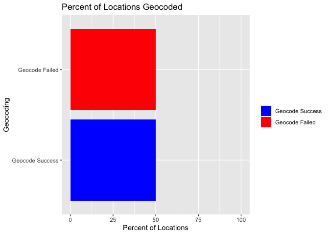
How effective was our geocoding?
geocoded_data %>%
  percent_located_locations()

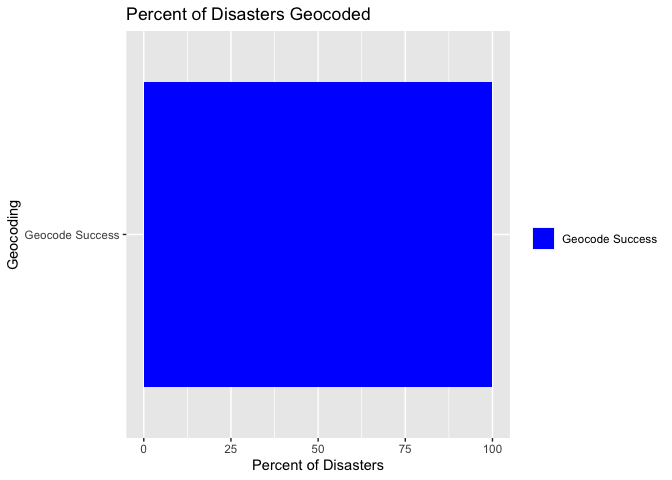
geocoded_data %>%
  percent_located_disasters()
Check if the locations are in a Lat Long Box!!
geocoded_data <- geocoded_data %>%
  located_in_box(top_left_lat = 0,
                 top_left_lng = 35,
                 bottom_right_lat = -6,
                 bottom_right_lng = 40)
geocoded_data %>%
  select(`Dis No`, Location,location_word, lat, lng, in_box)
#> # A tibble: 6 x 6
#>   `Dis No`   Location                          location_word    lat   lng in_box
#>   <chr>      <chr>                             <chr>          <dbl> <dbl> <lgl>
#> 1 2019-0515… Handeni district (Tanga Region)   handeni       -5.55   38.3 TRUE
#> 2 2019-0515… Handeni district (Tanga Region)   tanga         -5.07   39.1 TRUE
#> 3 2019-0562… Mwanza district                   mwanza        -2.52   32.9 FALSE
#> 4 2020-0164… West Pokot, Elgeyo Marakwet, Kis… west pokot     1.75   35.2 FALSE
#> 5 2020-0164… West Pokot, Elgeyo Marakwet, Kis… elgeyo marak…  0.516  35.5 FALSE
#> 6 2020-0164… West Pokot, Elgeyo Marakwet, Kis… kisumu        -0.102  34.8 FALSE
Check if Locations are in Shapefile!
geocoded_data %>%
  located_in_shapefile(shapefile_name = s_file_name) %>%
  select(`Dis No`, Location, location_word, lat, lng, in_box, in_shape)
#> Reading layer `SH_mask' from data source `/Users/ramkripa/Desktop/Projects/emdat_proj/shape_data/SH_mask.shp' using driver `ESRI Shapefile'
#> Simple feature collection with 1 feature and 1 field
#> geometry type:  MULTIPOLYGON
#> dimension:      XY
#> bbox:           xmin: -178.9 ymin: -50 xmax: 179.85 ymax: 50
#> geographic CRS: WGS 84
#> Warning: `rename_()` is deprecated as of dplyr 0.7.0.
#> Please use `rename()` instead.
#> This warning is displayed once every 8 hours.
#> Call `lifecycle::last_warnings()` to see where this warning was generated.
#> although coordinates are longitude/latitude, st_contains assumes that they are planar
#> # A tibble: 6 x 7
#>   `Dis No`   Location                 location_word    lat   lng in_box in_shape
#>   <chr>      <chr>                    <chr>          <dbl> <dbl> <lgl>  <lgl>
#> 1 2019-0515… Handeni district (Tanga… handeni       -5.55   38.3 TRUE   TRUE
#> 2 2019-0515… Handeni district (Tanga… tanga         -5.07   39.1 TRUE   TRUE
#> 3 2019-0562… Mwanza district          mwanza        -2.52   32.9 FALSE  FALSE
#> 4 2020-0164… West Pokot, Elgeyo Mara… west pokot     1.75   35.2 FALSE  TRUE
#> 5 2020-0164… West Pokot, Elgeyo Mara… elgeyo marak…  0.516  35.5 FALSE  TRUE
#> 6 2020-0164… West Pokot, Elgeyo Mara… kisumu        -0.102  34.8 FALSE  TRUE
Want to re-nest the location data?
geocoded_data %>%
  nest_locations() %>%
  select(`Dis No`, location_data)
#> # A tibble: 6 x 2
#>   `Dis No`           location_data
#>   <chr>         <list<tbl_df[,4]>>
#> 1 2019-0515-TZA            [2 × 4]
#> 2 2019-0515-TZA            [2 × 4]
#> 3 2019-0562-TZA            [1 × 4]
#> 4 2020-0164-KEN            [3 × 4]
#> 5 2020-0164-KEN            [3 × 4]
#> 6 2020-0164-KEN            [3 × 4]